Smarter planning starts here: Sign up for PIONEER™ before year-end and get Risk & Rehab FREE for 12 months.Learn More

PIONEER™

From CCTV Capture to cloud data storage and Digital Submittal, PIONEER is the end-to-end AI solution for intelligent, automated, rapid assessment.
Man wearing glasses and a dark shirt intently looking at two computer monitors displaying codes and an inspection report dashboard.

Serving over 130 million people

Keeping stakeholders in the loop has never been easier

Create notifications, assign tasks, and review and resolve your issues collaboratively to drive your maintenance and capital planning decisions. Annotate inspections (independently of the Exchange Database) to flag issues and make comments to teammates and stakeholders. There is no cap on project viewer seats, so you can collaborate with as many team members as you need to.
Screenshot of a task management interface showing point repair candidates with comments, user emails, and a review tasks panel listing duplicate video and related inspections.
Dashboard of SewerAI Real Time Risk Analyzer showing Salt Lake City map with color-coded risk zones and charts of likelihood versus consequence of failure.

Analytics and data visualization

Benchmark against tens of millions of feet of data managed within PIONEER. Utilize our customizable analytics tools to quantify metrics for the Likelihood of Failure (LoF) and Consequence of Failure (CoF). Combine PIONEER’s collaborative power with AutoCode™'s automatic coding to double your daily field production.

The only SOC 2 Type II Compliant Underground Infrastructure Management Platform

At SewerAI, data security isn’t an add-on — it’s built in. We’re proud to be the only underground infrastructure management platform on the market with SOC 2 Type II compliance, ensuring your data is handled with the highest standards of security, availability, and confidentiality.
Digital interface with a glowing shield and lock icon representing data security and cybersecurity.

Onboard in less than an hour

Unlimited storage. 

Unlimited possibilities.

Over 22,000 Miles 

under management

Explore PIONEER features

Screenshot of an email from SewerAI confirming digital submittal acceptance by Miles Lanyard for PO 5678 September work, overlaid with a software interface showing inspection submissions and a digital acceptance form.

Digital Submittals

Share projects instantly via emailed links to clients and stakeholders for review on the web. Streamline approvals by enabling stakeholders to accept, comment, share with others, and (if needed) download all the deliverables.
Interactive map showing Knoxville, TN with overlaid gravity mains and sewer line layers highlighted in blue and green, and a sidebar for layer management.

GIS Mapping

Collaborate like never before with GIS mapping in PIONEER, in the field or in the office, you can utilize geographic data and map layers to manage your wastewater infrastructure assets, pull GIS asset data into CCTV inspections while in the field, and support better decision-making.
Project settings panel open showing details for project Richardsonville-12975 with goal state Autocode Complete, specs selections, contract dates, project status, and fields for planned footage and count.

Project Management Dashboard

Work efficiently, collaborate effectively, and enhance overall productivity inside PIONEER's dashboard. Our interface lets you and your team interact with inspections intuitively, regardless of whether you are in the office or the field.
Man in safety vest monitoring two screens showing close-up insect images and circular inspection data.

On-Truck Solution

Easily capture information, create reports, and sync data from the field. Save your CCTV data offline and online for NASSCO PACP™ and LACP™ deliverables. Install and use PIONEER in your fleet at NO COST with your SewerAI subscription.
User interface displaying inspection data and video controls for pipeline assessment with summary details and image thumbnails on the right.

Auto Update and Format Inspection Videos

Customize inspection videos to your organization's standards. Adjust colors, text styles, audio overlays, and displayed fields. Choose from text-only or text and audio, initial header splash screen, running text, observation overlays, distance counter, and more.
Sewer3D software interface showing a side-by-side view of a sewer pipe photo and its 3D model with depth measurements.

3D Model and Photogrammetry

Render detailed textured 3D models of manhole structures with an affordable “prosumer” camera, complete with 360 video playback, virtual pan, tilt, zoom, vertical distance, and clock position orientation.

PIONEER Platform

CCTV, Digital SideScans, and Manholes (MHs)
NASSCO Certified (PACP, LACP, MACP) for Import (v7, v6, and v4) 
and Export (v7, and v6)
The only SOC 2 Type II Compliant Underground Infrastructure Management Platform
Unlimited storage and streaming included
Real-time collaboration tools
Unlimited viewer seats for collaboration
Works on iOS and Android mobile devices
Traditional and digital submittals 
of deliverables
1-click condition assessment, assisted by AI Computer Vision
Secure access on any device, at any time, from anywhere, and so much more
Two construction workers wearing blue hard hats and safety vests looking at a laptop behind a yellow barricade on a sidewalk.

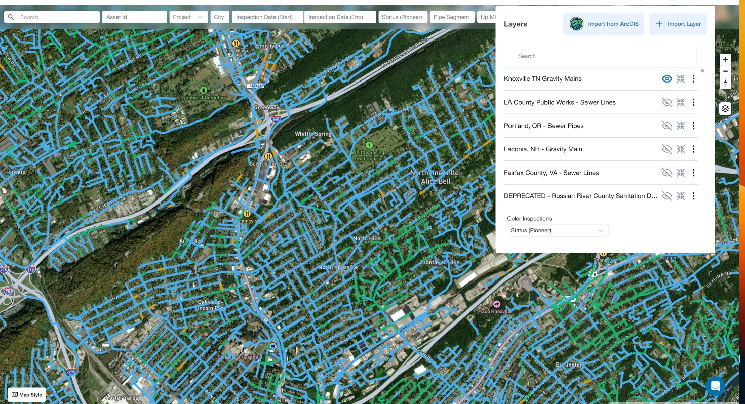
When I saw SewerAI’s interface, it was head and shoulders above anything else I had seen up until that point. The ease of use, the ability to customize data views. Just everything.

-  
James Cartafalsa
,  
Collection System Manager/Information Officer, Delaware County Regional Water Quality Control Authority